HoudahGeo 6.4.3
Free Trial Version
Publisher Description
HoudahGeo is a photo geotagging tool. It tags photos with location coordinates and names.
HoudahGeo is used by travelers and professionals alike. Some use location information to organize and find photos. Others need to add GPS coordinates to photos in order to assess roadwork damages, to record wildlife sightings, or to document environmental damages.
HoudahGeo writes EXIF and XMP geotags to JPEG and RAW image files. This creates a permanent record of where a photo was taken. Just like a GPS camera.
HoudahGeo is the only application that writes future-proof GPS tags to original images and also adds locations to photos in the Apple Photos, iPhoto and Aperture libraries.
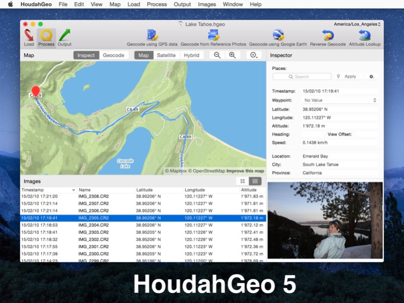
Geotagging follows an easy 3-step workflow: Load, Process, and Output.
* Load photos into a HoudahGeo project. Optionally add GPS track logs.
* Use the built-in map to assign or adjust photo locations. Use reverse geocoding to add location names.
* Write location information to the original image files. Export the project for viewing in Google Earth, Google My Maps, or FLickr.
Feature highlights:
* Write GPS data, location names, title, description, and keywords to EXIF, XMP and IPTC tags
* Works with JPEG, HEIF as well as a large number of RAW file formats. Supports XMP sidecar files.
* Integrates with Apple Photos, iPhoto, Aperture, and Adobe Lightroom Classic
* Automatic geocoding using GPS track logs
* Geocoding using reference photos taken using iPhone or a GPS camera
* Geocoding without a GPS. Use the built-in map to double-check, adjust, or assign locations
* Reverse geocoding fills in city, state and country names
* Notify Apple Photos, iPhoto or Aperture when places information has been updated
* Create Google Earth KML and KMZ files. View photos pinned along the path traveled
* Publish photos and KML files to Dropbox. Share images on a map
* Upload geotagged photos to Flickr
About HoudahGeo
HoudahGeo is a free trial software published in the Editors list of programs, part of Graphic Apps.
This Editors program is available in English, German. It was last updated on 23 April, 2024. HoudahGeo is compatible with the following operating systems: Mac.
The company that develops HoudahGeo is Houdah Software s. r.l. The latest version released by its developer is 6.4.3. This version was rated by 1 users of our site and has an average rating of 3.0.
The download we have available for HoudahGeo has a file size of 28.31 MB. Just click the green Download button above to start the downloading process. The program is listed on our website since 2023-12-17 and was downloaded 1,058 times. We have already checked if the download link is safe, however for your own protection we recommend that you scan the downloaded software with your antivirus. Your antivirus may detect the HoudahGeo as malware if the download link is broken.
How to install HoudahGeo on your Windows device:
- Click on the Download button on our website. This will start the download from the website of the developer.
- Once the HoudahGeo is downloaded click on it to start the setup process (assuming you are on a desktop computer).
- When the installation is finished you should be able to see and run the program.
